New Zealand
South Island West Coast, Part 2
Southern West Coast, Wanaka, and Mt. Aspiring National Park
 |
Sunset at Lake Matheson
|
Franz Josef and Fox Glaciers
 |
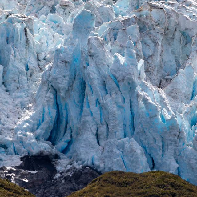
| Franz Josef Glacier |
Franz Josef and Fox Glaciers are a huge draw to the west coast of the South Island of New Zealand. It is one of the rare places where you can see beach, wetlands, rainforest and Glacier all in one view. There are very few places on earth where you can take a picture with all of these elements present in a single photograph. The Franz Josef and Fox Glaciers are really only two of many glaciers present in the southern alps mountain range on the South Island. They are, however, two of the most accessible. There are villages named after each of the glaciers which are separated by about a 30 minute drive.
 |
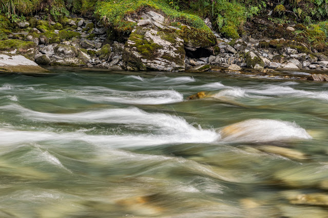
| Callery Gorge |
There are many hiking trails in and around both villages of Franz Josef and Fox. An exceptionally beautiful track is to Callery Gorge. This is a walking trail that starts right in town. The Callery Gorge Track is a 3.1 mile out and back trail with an easy to moderate difficulty level with an elevation gain of 554 ft. It leads to a beautiful aqua blue river surrounded by rock and lush greenery. It also has a few waterfalls for good measure.
 |
| Callery Gorge |
 |
| Callery Gorge |
 |
| Callery Gorge |
 |
| Franz Josef Glacier |
The sentinel rock walk is an easy half mile walk to see the Franz Josef Glacier. This is about as close as you can get to the Franz Josef Glacier without doing a guided glacier walk or helicopter ride.
 |
| Fox Glacier |
The Fox Glacier South Side Walkway is another relatively easy 4 mile out and back hike to see fox glacier.
A very popular way to see the glaciers up close is by a helicopter ride. There are many different companies that offer helicopter tours. The tours leave from Franz Josef, Wanaka, Queenstown, and even Mt. Cook. One caution I would give to anyone desperately wanting to do a helicopter glacier tour is to give yourself a few days in this area. Because they are on the western side of the alps, there are a lot of cloudy and rainy days when the helicopters cannot fly. The day before our tour, all helicopter rides were grounded due to poor visibility. The day that we had scheduled our tour was a beautiful nearly cloud free day in Franz Josef, but our tour was still delayed for about 30 minutes due to dense fog in the area where the helicopters depart. So leave a bit of flexibility if you can for mother nature!
 |
| Glacier Country Helicopters |
All that being said, we decided to book our helicopter tour with Glacier Country Helicopters. They are a family owned and operated helicopter tour company and we enjoyed our tour immensely!!
The above video is a short compilation of our tour. We saw Franz Josef, Fox, and Tasman Glaciers to just name a few. Below are a few of the photos John was able to capture during flight.
 |
| Small glacial lake in the mountains |
Lake Matheson viewpoint of southern alps and Mt Cook and Mt Tasman
 |
| Sunrise at Lake Matheson |
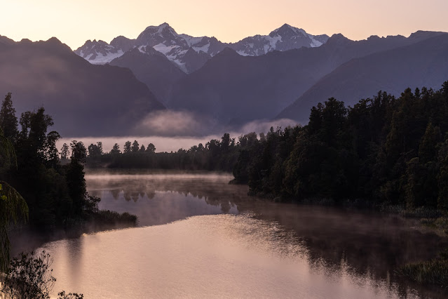
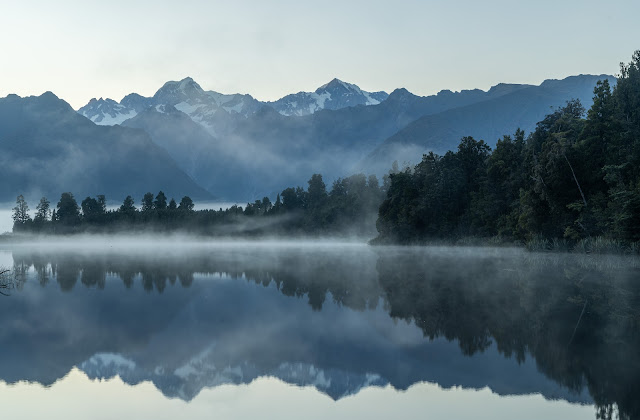
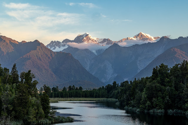
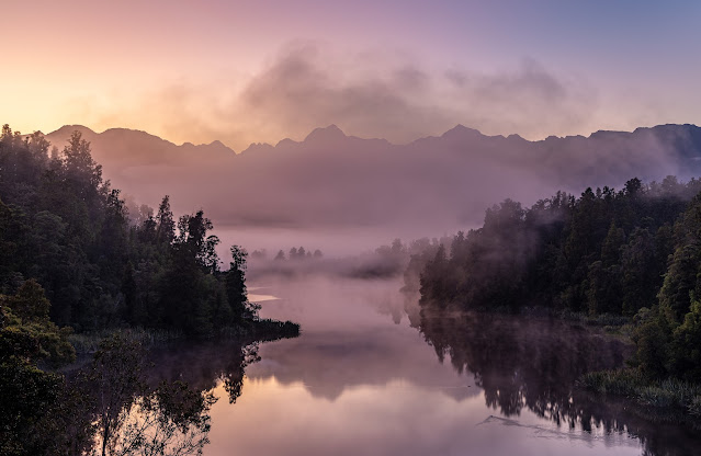
Lake Matheson is a small lake near the village of Fox Glacier which is famous for the beautiful reflections of the peaks of Mt. Tasman and Mt. Cook in the distance when the water is still and winds are calm. Photographers from all around come to get photographs of this iconic reflection. The weather doesn't always cooperate, but when it does it is magical. The best times to come are at sunrise and sunset for these iconic shots as this is when the winds are typically the calmest. But BEWARE of the SANDFLIES, they are TERRIBLE here and many areas on the south island.
 |
| Sunrise at Lake Matheson |
 |
| Sunset at Lake Matheson |
 |
| Sunset at Lake Matheson |
John made this trek 3 times trying his luck for good weather. Twice at sunrise and once at sunset and here are some of the best photographs he captured.
 |
| Sunset at Lake Matheson |
 |
| Sunrise at Lake Matheson |
 |
| Sunrise at Lake Matheson |
 |
| Sunrise at Lake Matheson |
Scenic Views from west coast of South Island
 |
| Reflections from Peter's Pool (Track is in the Village of Franz Josef) |
 |
| Reflections from Peter's Pool |
 |
| Thundercreek Falls |
 |
| Fantail Falls |
 |
View from back porch of Makarora Airbnb
|
 |
| Sunrise at our Makarora Airbnb |
 |
| Mountain View from Pleasant Flats Recreation Area |
 |
| Mountain View from Blue Pools Carpark |
 |
| Fern coil |
 |
| Fern Coil |
Blue Pools |
| Blue Pools |
 |
| Blue Pools |
The blue pools track is officially closed as the bridge over the river is under construction. However, if you don't mind getting wet walking across the river, you can still get to the blue pools and see their crystal clear water. Again, BEWARE of the SANDFLIES!!! They just swarm you here. I decided to bail as the water was a bit deeper than I wanted, but John made the trek across the river and brought back the pictures to show for it (and many sandfly bites on his ankles and feet which were exposed for the river crossing).
 |
| Blue Pools |
 |
| Blue Pools |
 |
| Blue Pools |
 |
| Blue River |
 |
| Blue River |
Wanaka and Mt Aspiring National Park
 |
Lake Wanaka
It was an absolutely stunning drive from Makarora to Wanaka. Lakes Wanaka and Hawea are huge and surrounded by mountains all around. We chose to stay in Wanaka to be close to Mt Aspiring National Park with many hikes we wanted to do, but this is also about an hour from Queenstown. |
 |
Lake Hawea
|
 |
Lake Hawea
|
 |
| Lake Hawea |
 |
| Tree which is typically in the middle of Lake Wanaka (water levels are down, so no longer in the water) |
There is a tree that has grown in the periphery of Lake Wanaka and is typically surrounded by water. It has gone viral on social media as #thatwanakatree so we had to go check it out. Unfortunately, the water levels are down right now, so the tree was not surrounded by water when we went. The above photo is another tree (not the same tree labeled as #thatwanakatree) with the same features just a bit down the coast.
While exploring Mt. Aspiring NP, we decided to do three major hikes: Rob Roy Glacier Track, Roys Peak and Diamond Lake and Rocky Mountain Trail. We liked them all, but Rob Roy Glacier Track blew me away!!!
Rob Roy Glacier Track
 |
| Lower Observation Point |
 |
Matukituki River
|
 |
| Matukituki River |
 |
| Bridal Veil Falls |
 |
| Bridal Veil Falls |
 |
| Lower Observation Point |
The Rob Roy Glacier Track is a 6.4 mile out and back trail with a reported 1,548 ft elevation gain (though my apple watch calculated more like an 8.2 miles and a 1,766 ft elevation gain, but who is counting ...). It was such a breathtakingly beautiful hike, it rates up in the top 2 of all hikes we have done while in New Zealand. The Tongoriro Alpine Cossing track that we did at the end of January while in Taupo is the other hike in the top 2. We were so close to the glaciers and could see so many waterfalls all along the slope flowing from the glacier. If you are going to be in the area and can only do one day hike, I recommend this one!!!
 |
| Lower Observation Point |
 |
| Rob Roy Glacier upper observation point |
This was our view while eating our lunch the day we did this hike!! Unbelievable.
 |
| Rob Roy Glacier |
 |
| Rob Roy Glacier |
 |
| Rob Roy Glacier |
 |
| Rob Roy Glacier |
 |
| Rob Roy Glacier |
 |
| Rob Roy Glacier |
 |
| One of the waterfalls flowing from the Rob Roy Glacier |
 |
| Rob Roy Glacial River |
 |
| Rob Roy Glacial River |
 |
| Waterfall along the road on private property (photo from the road with a telephoto lens) |
Roys Peak Track
 |
| View of Roys Peak from the carpark |
 |
| View from the top of Roys Peak (looking down at the car park - somewhere down there...) |
Roys Peak is an enormously popular hike to do while in the area. Many people do this hike for sunrise so if you decide to do this hike for sunrise and arrive at the parking lot around 3:30am (yes 3:30am, don't worry you will not be the only crazy one) and maybe you will find a parking spot. Roys peak is a 10 mile out and back hike with a 4,212 ft elevation gain. You are basically walking straight up for 5 miles. This was not the hike for me, but John couldn't help himself, he had to do it. He was rewarded with beautiful views of Lake Wanaka and the surrounding area.
Even near the top of Roys Peak Track, there are sheep enjoying the view and keeping you company! :)
Diamond Lake and Rocky Mountain Trails
The Diamond Lake and Rocky Mountain Track was a 4.4 mile loop trail with a 1,591 ft elevation gain. At the top of the Rocky Mountain Trail we had panoramic views all around similar to those seen on Roys Peak Trail about one third of the elevation, but one quarter of the effort!
Queenstown
 |
| View from the center of Queenstown looking down Lake Wakatipu |
We only spent an afternoon in Queenstown, but it is by far the coolest city I have seen in New Zealand. It is a big draw for the area and has named itself the 'Adventure Capital of the World' because you can do all kinds of activities here, including bungy jumping, jet boating, skydiving, paragliding, and mountain biking to name a few. It has its downtown right on the shores of Lake Wakatipu with activities, shopping, and many dining options. There is also a Skyline attraction where you can ride a gondola up and luge down. We did not end up doing this but it looked fun! We did make a stop at the famed Fergburger, which claims to have the best burger in New Zealand. It was a crazy long line, but it went fast. We enjoyed our Fergburger and fries, which were definitely worth the wait! One caveat, Queenstown is a very popular city with locals and tourists alike, so it is very busy like any tourist town. But I would definitely come back and spend a little more time here!
 |
| Fergburger in Queenstown |
With that we are on our way to Te Anau and Fiorland National Park...
Things in the southern west coast area that we enjoyed most and would do again:
1. Rob Roy Glacier Track
2. Helicopter Glacier Tour
3. Callery Gorge Track
4. Lake Matheson
5. Queenstown (not technically part of the west coast, but close
enough)
Additional Costs (in NZD):Glacier Country Helicopter Tour - $680pp for 45 min ride
Coming soon...
Fiordland National Park, Including: Te Anau, Milford and Doubtful Sounds


Comments
Post a Comment