New Zealand
South Island
Mt. Cook/Aoraki National Park and Lake Tekapo
 |
| Aoraki/Mt. Cook NP and Hooker Lake view from Hooker Valley Track |
The most amazing thing about New Zealand is the ever changing landscapes practically every turn you make. After leaving the southern coast, we traveled north and inland to the eastern side of the southern alps to spend some time in Lake Tekapo and Aoraki/Mt. Cook.
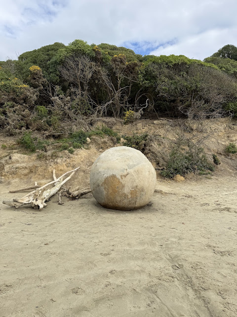
As we drove up the southeast coast on our way to Lake Tekapo, we stopped to check out the Moeraki boulders.
Moeraki boulders are large spherical rocks sitting along the beach. They can be seen singly or in clusters predominantly in a linear fashion. The boulders range from 2 to about 6 feet in diameter. The boulders are grey/brown with septations that make them look like a turtle shell. The boulders are formed from mud, silt and clay, while the septations are composed of calcite crystals.
 |
| Large boulder sitting high on the beach. |
 |
| Boulder that has cracked open to reveal a hollow center |
 |
Clusters of boulders |

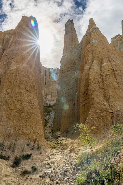
Along the drive inland, we stopped at the Clay Cliffs. This site is actually on private property, but for a modest fee ($10 per car), the land owner allows access for the public.
 |
| Clay Cliffs |
 |
| Clay Cliffs |
 |
| Clay Cliffs |
 |
| Clay Cliffs |
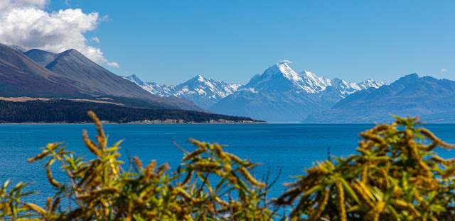
Then after just 3 hours of driving we got our first views of Mt. Cook/Aoraki. Though our first glimpse was not clear due to the clouds, we learned our lesson with Mt. Taranaki on the North Island, take a picture if you can mostly see the mountain as you never know whether you will see it again.
 |
| Aoraki/Mt. Cook |
Aoraki is the Maori name for Mt. Cook. Why the two names? There has been a big push in recent years to include or change the names of places back to the Maori names. The Maori people were the first settlers of Aotearoa/New Zealand.
 |
| Same photo as above, with unobscured view of Mt. Cook/Aoraki |
 |
| Mt. Cook and its reflection |
Hooker Valley Track is a very popular hike and is considered to be one of the best day hikes in Mt. Cook National Park. It is a 6 mile out and back hike that is not difficult and takes about 3 hr to complete. The track crosses the Hooker River 3 times with stunning views of both Hooker and Muller Lakes, as well as great views of Mueller Glacier. |
| Views of mountain glaciers, Hooker Lake and glacial river along Hooker Valley Track |
 |
| Views of Hooker Lake with chunks of glacial ice berg |
 |
| Hooker Lake view |
We also hiked over to Tasman Lake with views of Tasman Glacier and Tasman River. This is a short easy track with beautiful view of Tasman Lake.
 |
| Tasman Lake and Glacier |
At the end of the lake you can see piles of dirt and a sharp face of white and blue. This is the end of Tasman Glacier, which is the longest glacier in New Zealand at 14 miles long. The terminal face of the glacier extends 160 feet in height above the water and at least extends 300 feet below the surface. The dirt and rock are deposited on the glacier after rock slides caused by the pushing of the glacier. The rock and dirt are actually forming an insulating layer protecting this segment of the glacier from melt to some degree.
 |
Tasman Lake and Glacier
|
 |
| Tasman River |
 |
| Tasman Lake at sunset |
 |
| Tasman Lake at sunset |
 |
| View of the blue pools adjacent to the Tasman Lake track |
 |
| Church of the Good Shepherd |
On the southern shore of Lake Tepako, you will find a small church with a grand view. The Church of the Good Shepherd has great notoriety for its gorgeous views and as foreground for astrophotography photos of the Milky Way and other night sky views. As John also loves astrophotography, of course we had to try to get some of his very own photos of the Milky Way. This area is a designated Dark Skies area, but we had to work around the moon rise and setting times to optimize the darkness of the sky.
 |
Galactic core of the Milky Way
|
 |
| Milky Way core over the Church of the Good Shepherd |
I would say he got some great photos, so well worth the getting up at 3am to shoot the Milky Way before sunrise.
 |
| Southern Cross with Church of the Good Shepherd in the foreground |
 |
| Mt. Cook in the moonlight |
 |
| Looking up the Tasman Glacier |
 |
| Looking up the Tasman Glacier |
 |
| Side of Tasman Glacier where it meets the mountainside |
 |
| Tasman Glacier |
 |
| Small Vertical Crevasse in Tasman Glacier, our guide for size |
 |
| Small Vertical Crevasse in Tasman Glacier |
 |
| Small Vertical Crevasse in Tasman Glacier from inside |
 |
| John Climbing out of the vertical crevasse |
 |
| Cool colors in the glacier |
 |
| Cool colors in the glacier |
 |
| Small river flowing on Tasman Glacier from ice melt |
 |
| Old ice crystal (the older the ice, the larger the crystal) |
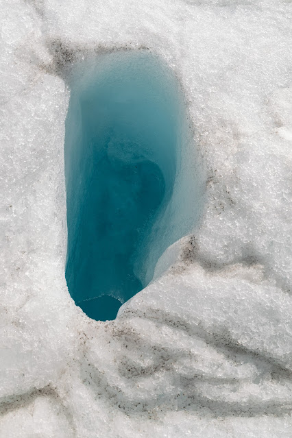
On the glacier, there are linear striations everywhere you look. Some of these are snow in the process of being compacted into glacial ice and some are large chunks of ice crystals. Our guide told us these are old ice. She said the older the ice the bigger the chunks. How did it get to the top you ask? She said the glacier is in constant motion and as it comes into contact with the bottom or the sides of the mountain it shifts and flows just like water in a river, and that constant shifting results in old ice being shifted up.
 |
| Lake Tekapo |
Mt John Observatory is also located up on the top of a mountain along Lake Tekapo. The Dark Skies Project holds regular star watching activities at various times throughout the night. Make sure you buy your tickets for these star watching activities ahead of time if this is something you would like to do. We cannot give any comment on quality as we did not attend any of their sessions. A blog post from this trip would not complete without a few waterfall pictures :).
 |
| Acland Falls |
 |
Acland Falls
|
 |
| Emily Falls |
 |
| Emily Falls |
 |
| Emily Falls |
 |
| Emily Falls |
 |
| Emily Falls |
We spent over a week in Lake Tekapo and Mt. Cook NP area. Part of the reason for staying so long in this area was due to the dark skies designation and for John to have time to do some astrophotography. The weather is notoriously unpredictable in this region (all of NZ really) and there was no guarantee of clear skies, so we chose to spend a few extra days here to maximize the opportunity for astrophotography. However, most of our daytime activities were spent in Mt. Cook NP which was about 75-80 min from Lake Tekapo. If I were to do this again, I would split the time between Lake Tekapo and Mt Cook Village, however, there are less lodging options and fewer restaurants in Mt Cook Village, which is also a consideration to keep in mind. That being said, we thoroughly enjoyed our time in this region.Things in Mt. Cook National Park and Lake Tekapo that we enjoyed most and would do again:
1. Hooker Valley Track
2. Hike on Tasman Glacier
3. Dark Skies Milky Way viewing
4. Waterfall hikes
Coming soon...
Christchurch and surrounding area


Comments
Post a Comment